2023 Vol. 29, No. 4
column
2023, 29(4): .
Abstract:
2023, 29(4): 385-400.
doi: 10.3724/j.1006-8775.2023.029
Abstract:
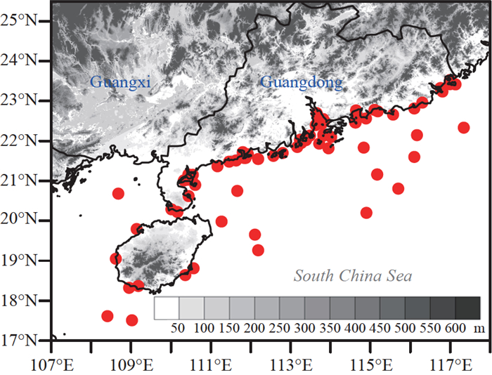
Wind gusts are common environmental hazards that can damage buildings, bridges, aircraft, and cruise ships and interrupt electric power distribution, air traffic, waterway transport and port operations. Accurately predicting peak wind gusts in numerical models is essential for saving lives and preventing economic losses. This study investigates the climatology of peak wind gusts and their associated gust factors (GFs) using observations in the coastal and open ocean of the northern South China Sea (NSCS), where severe gust-producing weather occurs throughout the year. The stratified climatology demonstrates that the peak wind gust and GF vary with seasons and particularly with weather types. Based on the inversely proportional relationship between the GF and mean wind speed (MWS), a variety of GF models are constructed through least squares regression analysis. Peak gust speed (PGS) forecasts are obtained through the GF models by multiplying the GFs by observed wind speeds rather than forecasted wind speeds. The errors are thus entirely due to the representation of the GF models. The GF models are improved with weather-adaptive GFs, as evaluated by the stratified MWS. Nevertheless, these weather-adaptive GF models show negative bias for predicting stronger PGSs due to insufficient data representation of the extreme wind gusts. The evaluation of the above models provides insight into maximizing the performance of GF models. This study further proposes a stratified process for forecasting peak wind gusts for routine operations.
Wind gusts are common environmental hazards that can damage buildings, bridges, aircraft, and cruise ships and interrupt electric power distribution, air traffic, waterway transport and port operations. Accurately predicting peak wind gusts in numerical models is essential for saving lives and preventing economic losses. This study investigates the climatology of peak wind gusts and their associated gust factors (GFs) using observations in the coastal and open ocean of the northern South China Sea (NSCS), where severe gust-producing weather occurs throughout the year. The stratified climatology demonstrates that the peak wind gust and GF vary with seasons and particularly with weather types. Based on the inversely proportional relationship between the GF and mean wind speed (MWS), a variety of GF models are constructed through least squares regression analysis. Peak gust speed (PGS) forecasts are obtained through the GF models by multiplying the GFs by observed wind speeds rather than forecasted wind speeds. The errors are thus entirely due to the representation of the GF models. The GF models are improved with weather-adaptive GFs, as evaluated by the stratified MWS. Nevertheless, these weather-adaptive GF models show negative bias for predicting stronger PGSs due to insufficient data representation of the extreme wind gusts. The evaluation of the above models provides insight into maximizing the performance of GF models. This study further proposes a stratified process for forecasting peak wind gusts for routine operations.
2023, 29(4): 401-409.
doi: 10.3724/j.1006-8775.2023.030
Abstract:
Black carbon (BC) is the strongest visible-light-absorbing aerosol component in the atmosphere, with a significant impact on Earth's radiative budget. Accurate measurement of BC light absorption is crucial for estimating its radiative effect. The micro-aethalometer model 200 (MA200) by AethLabs, USA, offers high-time-resolution measurement of the multi-wavelength absorption coefficient (σab) within 1 s, making it widely used in aerial measurement due to its compact size and light weight. However, the reliability of the measured σab has not been extensively studied in previous research. In this study, we evaluate the performance of MA200 by comparing σab measurements obtained from MA200 with those from the aethalometer model 33 (AE33) by Magee, USA. Our results revealed a significant variation in the determinant coefficient (R2) between σab measurements from MA200 and AE33, depending on the time resolution. The R2 increases from 0.1 to 0.5 and further to 0.97 as the time resolution of σab increases from 1 s to 30 s and 60 s, respectively. We recommend a minimum time resolution of 30 s for stable σab measurements using MA200. Moreover, we determine σab from attenuation coefficient (σATN) measured by MA200 as σab = (σATN – σ0)/CMA, where σ0 ranges from – 15.3 Mm–1 to – 6.4 Mm–1 and CMA ranges from 2.65 to 3.21. Correcting the measured σab based on the findings of this study can provide reliable results for estimating the radiative effects of BC.
Black carbon (BC) is the strongest visible-light-absorbing aerosol component in the atmosphere, with a significant impact on Earth's radiative budget. Accurate measurement of BC light absorption is crucial for estimating its radiative effect. The micro-aethalometer model 200 (MA200) by AethLabs, USA, offers high-time-resolution measurement of the multi-wavelength absorption coefficient (σab) within 1 s, making it widely used in aerial measurement due to its compact size and light weight. However, the reliability of the measured σab has not been extensively studied in previous research. In this study, we evaluate the performance of MA200 by comparing σab measurements obtained from MA200 with those from the aethalometer model 33 (AE33) by Magee, USA. Our results revealed a significant variation in the determinant coefficient (R2) between σab measurements from MA200 and AE33, depending on the time resolution. The R2 increases from 0.1 to 0.5 and further to 0.97 as the time resolution of σab increases from 1 s to 30 s and 60 s, respectively. We recommend a minimum time resolution of 30 s for stable σab measurements using MA200. Moreover, we determine σab from attenuation coefficient (σATN) measured by MA200 as σab = (σATN – σ0)/CMA, where σ0 ranges from – 15.3 Mm–1 to – 6.4 Mm–1 and CMA ranges from 2.65 to 3.21. Correcting the measured σab based on the findings of this study can provide reliable results for estimating the radiative effects of BC.
2023, 29(4): 410-430.
doi: 10.3724/j.1006-8775.2023.031
Abstract:
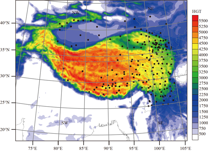
Considering the complex topographic forcing and large cryosphere concentration, the present study utilized the polar-optimized WRF model (Polar WRF) to conduct downscaling simulations over the Qinghai-Tibet Plateau (TP) and its surrounding regions. Multi-group experiments with the 10 km horizontal resolution are used to evaluate the modeling of precipitation. Firstly, on the basis of the model ground surface properties upgrade and the optimized Noah-MP, the "better-performing" configuration suite for modeling precipitation is comprehensively examined. Various model parameters such as nudging options, five cumulus parameterization schemes, two planetary boundary layer schemes, and six microphysics schemes are investigated to further refine the Polar WRF configuration. Moreover, the precipitation simulation for a full calendar year is compared with multiple reanalyses and observations. The simulations demonstrate that the Polar WRF model successfully captures the general features of precipitation over this region and is sensitive to model parameters. Based on the results, it is recommended to use grid nudging with q intensity coefficient of 0.0002, the multi-scale kain-fritsch cumulus parameterization, the Yonsei University boundary layer scheme, and the Morrison 2-mom microphysics with reduced default droplet concentration value of 100 cm–3. Overall, the model performance is better than the ERA-interim and TRMM 3b42. It is comparable to, and in some cases slightly better than, the CRA-Land, especially in the prediction for the western part of the plateau where in situ observations are limited, and the cryosphere-atmosphere interaction is more pronounced.
Considering the complex topographic forcing and large cryosphere concentration, the present study utilized the polar-optimized WRF model (Polar WRF) to conduct downscaling simulations over the Qinghai-Tibet Plateau (TP) and its surrounding regions. Multi-group experiments with the 10 km horizontal resolution are used to evaluate the modeling of precipitation. Firstly, on the basis of the model ground surface properties upgrade and the optimized Noah-MP, the "better-performing" configuration suite for modeling precipitation is comprehensively examined. Various model parameters such as nudging options, five cumulus parameterization schemes, two planetary boundary layer schemes, and six microphysics schemes are investigated to further refine the Polar WRF configuration. Moreover, the precipitation simulation for a full calendar year is compared with multiple reanalyses and observations. The simulations demonstrate that the Polar WRF model successfully captures the general features of precipitation over this region and is sensitive to model parameters. Based on the results, it is recommended to use grid nudging with q intensity coefficient of 0.0002, the multi-scale kain-fritsch cumulus parameterization, the Yonsei University boundary layer scheme, and the Morrison 2-mom microphysics with reduced default droplet concentration value of 100 cm–3. Overall, the model performance is better than the ERA-interim and TRMM 3b42. It is comparable to, and in some cases slightly better than, the CRA-Land, especially in the prediction for the western part of the plateau where in situ observations are limited, and the cryosphere-atmosphere interaction is more pronounced.
2023, 29(4): 431-447.
doi: 10.3724/j.1006-8775.2023.032
Abstract:
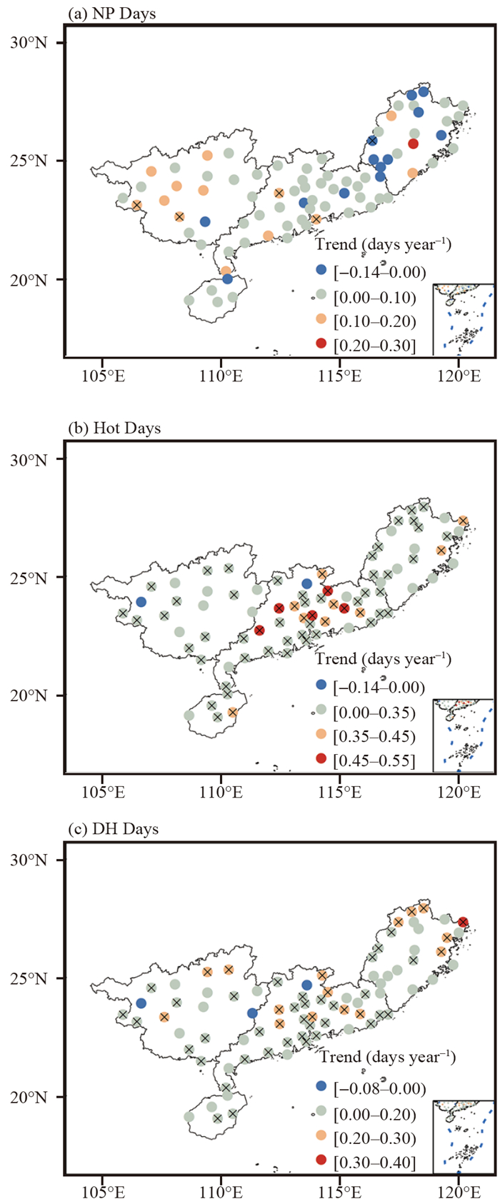
The frequent occurrence of dry and hot (DH) days in South China in summer has a negative impact on social development and human health. This study explored the variation characteristics of DH days and the possible reasons for this knotty problem. The findings revealed a notable increase in the number of DH days across most stations, indicating a significant upward trend. Additionally, DH events were observed to occur frequently. The number of DH days increased during 1970–1990, decreased from 1991 to 1997, and stayed stable after 1997. The key climate factors affecting the interannual variability of the number of DH days were the Indian Ocean Basin warming (IOBW) in spring and the East Asian Summer Monsoon (EASM). Compared with the negative phase of IOBW, in the positive phase of IOBW, 500 hPa and 850 hPa geopotential height enhanced, the West Pacific subtropical high strengthened and extended abnormally to the west, more solar radiation reached the surface, surface outgoing longwave radiation increased, and there was an anomalous anticyclone in eastern South China. The atmospheric circulation characteristics of the positive and negative phases of ESAM were opposite to those of IOBW, and the abnormal circulation of the positive (negative) phases of ESAM was unfavorable (favorable) for the increase in the number of DH days. A long-term prediction model for the number of summer DH days was established using multiple linear regression, incorporating the key climate factors. The correlation coefficient between the observed and predicted number of DH days was 0.65, and the root-mean-square error was 2.8. In addition, independent forecasts for 2019 showed a deviation of just 1 day. The results of the independent recovery test confirmed the stability of the model, providing evidence that climatic factors did have an impact on DH days in South China.
The frequent occurrence of dry and hot (DH) days in South China in summer has a negative impact on social development and human health. This study explored the variation characteristics of DH days and the possible reasons for this knotty problem. The findings revealed a notable increase in the number of DH days across most stations, indicating a significant upward trend. Additionally, DH events were observed to occur frequently. The number of DH days increased during 1970–1990, decreased from 1991 to 1997, and stayed stable after 1997. The key climate factors affecting the interannual variability of the number of DH days were the Indian Ocean Basin warming (IOBW) in spring and the East Asian Summer Monsoon (EASM). Compared with the negative phase of IOBW, in the positive phase of IOBW, 500 hPa and 850 hPa geopotential height enhanced, the West Pacific subtropical high strengthened and extended abnormally to the west, more solar radiation reached the surface, surface outgoing longwave radiation increased, and there was an anomalous anticyclone in eastern South China. The atmospheric circulation characteristics of the positive and negative phases of ESAM were opposite to those of IOBW, and the abnormal circulation of the positive (negative) phases of ESAM was unfavorable (favorable) for the increase in the number of DH days. A long-term prediction model for the number of summer DH days was established using multiple linear regression, incorporating the key climate factors. The correlation coefficient between the observed and predicted number of DH days was 0.65, and the root-mean-square error was 2.8. In addition, independent forecasts for 2019 showed a deviation of just 1 day. The results of the independent recovery test confirmed the stability of the model, providing evidence that climatic factors did have an impact on DH days in South China.
2023, 29(4): 448-459.
doi: 10.3724/j.1006-8775.2023.033
Abstract:
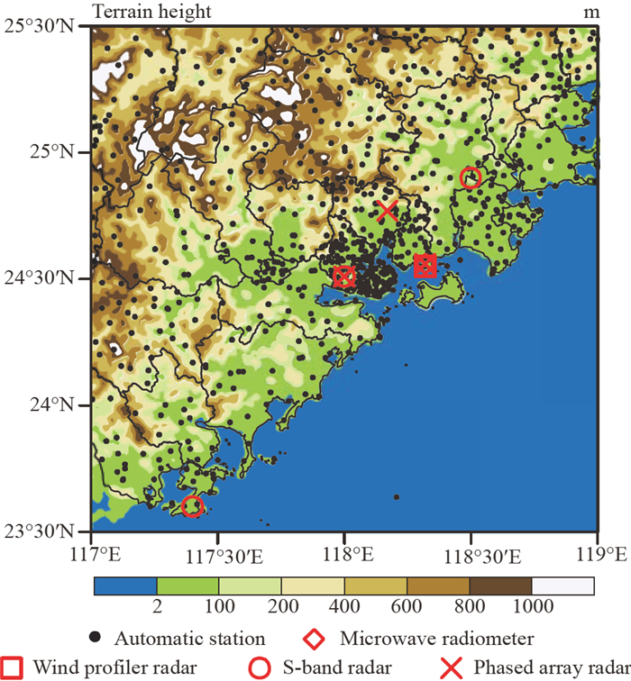
In August 2021, a warm-sector heavy rainfall event under the control of the western Pacific subtropical high occurred over the southeastern coast of China. Induced by a linearly shaped mesoscale convective system (MCS), this heavy rainfall event was characterized by localized heavy rainfall, high cumulative rainfall, and extreme rainfall intensity. Using various observational data, this study first analyzed the precipitation features and radar reflectivity evolution. It then examined the role of environmental conditions and the relationship between the ambient wind field and convective initiation (CI). Furthermore, the dynamic lifting mechanism within the organization of the MCS was revealed by employing multi-Doppler radar retrieval methods. Results demonstrated that the linearly shaped MCS, developed under the influence of the subtropical high, was the primary cause of the extreme rainfall event. High temperatures and humidity, coupled with the convergence of low-level southerly winds, established the environmental conditions for MCS development. The superposition of the convergence zone generated by the southerly winds in the boundary layer (925–1000 hPa) and the divergence zone in the lower layer (700–925 hPa) supplied dynamic lifting conditions for CI. Additionally, a long-term shear line (southerly southwesterly) offered favorable conditions for the organization of the linearly shaped MCS. The combined effects of strengthening low-level southerly winds and secondary circulation in mid-upper levels were influential factors in the development and maintenance of the linearly shaped MCS.
In August 2021, a warm-sector heavy rainfall event under the control of the western Pacific subtropical high occurred over the southeastern coast of China. Induced by a linearly shaped mesoscale convective system (MCS), this heavy rainfall event was characterized by localized heavy rainfall, high cumulative rainfall, and extreme rainfall intensity. Using various observational data, this study first analyzed the precipitation features and radar reflectivity evolution. It then examined the role of environmental conditions and the relationship between the ambient wind field and convective initiation (CI). Furthermore, the dynamic lifting mechanism within the organization of the MCS was revealed by employing multi-Doppler radar retrieval methods. Results demonstrated that the linearly shaped MCS, developed under the influence of the subtropical high, was the primary cause of the extreme rainfall event. High temperatures and humidity, coupled with the convergence of low-level southerly winds, established the environmental conditions for MCS development. The superposition of the convergence zone generated by the southerly winds in the boundary layer (925–1000 hPa) and the divergence zone in the lower layer (700–925 hPa) supplied dynamic lifting conditions for CI. Additionally, a long-term shear line (southerly southwesterly) offered favorable conditions for the organization of the linearly shaped MCS. The combined effects of strengthening low-level southerly winds and secondary circulation in mid-upper levels were influential factors in the development and maintenance of the linearly shaped MCS.
2023, 29(4): 460-472.
doi: 10.3724/j.1006-8775.2023.034
Abstract:
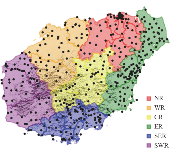
This study assesses the performance of three high-resolution regional numerical models in predicting hourly rainfall over Hainan Island from April to October for the years from 2020 to 2022. The rainfall amount, frequency, intensity, duration, and diurnal cycle are examined through zoning evaluation. The results show that the China Meteor-ological Administration Guangdong Rapid Update Assimilation Numerical Forecast System (CMA-GD) tends to forecast a higher occurrence of light precipitation. It underestimates the late afternoon precipitation and the occurrence of short-duration events. The China Meteorological Administration Shanghai Numerical Forecast Model System (CMA-SH9) reproduces excessive precipitation at a higher frequency and intensity throughout the island. It overestimates rainfall during the late afternoon and midnight periods. The simulated most frequent peak times of rainfall in CMA-SH9 are 0–1 hour deviations from the observed data. The China Meteorological Administration Mesoscale Weather Numerical Forecasting System (CMA-MESO) displays a similar pattern to rainfall observations but fails to replicate reasonable structure and diurnal variation of frequency-intensity. It underestimates the occurrence of long-duration events and overestimates related rainfall amounts from midnight to early morning. Notably, significant discrepancies are observed in the predictions of the three models for areas with complex terrain, such as the central, southeastern, and southwestern regions of Hainan Island.
This study assesses the performance of three high-resolution regional numerical models in predicting hourly rainfall over Hainan Island from April to October for the years from 2020 to 2022. The rainfall amount, frequency, intensity, duration, and diurnal cycle are examined through zoning evaluation. The results show that the China Meteor-ological Administration Guangdong Rapid Update Assimilation Numerical Forecast System (CMA-GD) tends to forecast a higher occurrence of light precipitation. It underestimates the late afternoon precipitation and the occurrence of short-duration events. The China Meteorological Administration Shanghai Numerical Forecast Model System (CMA-SH9) reproduces excessive precipitation at a higher frequency and intensity throughout the island. It overestimates rainfall during the late afternoon and midnight periods. The simulated most frequent peak times of rainfall in CMA-SH9 are 0–1 hour deviations from the observed data. The China Meteorological Administration Mesoscale Weather Numerical Forecasting System (CMA-MESO) displays a similar pattern to rainfall observations but fails to replicate reasonable structure and diurnal variation of frequency-intensity. It underestimates the occurrence of long-duration events and overestimates related rainfall amounts from midnight to early morning. Notably, significant discrepancies are observed in the predictions of the three models for areas with complex terrain, such as the central, southeastern, and southwestern regions of Hainan Island.
2023, 29(4): 473-481.
doi: 10.3724/j.1006-8775.2023.035
Abstract:
This study assesses the predictive capabilities of the CMA-GD model for wind speed prediction in two wind farms located in Hubei Province, China. The observed wind speeds at the height of 70m in wind turbines of two wind farms in Suizhou serve as the actual observation data for comparison and testing. At the same time, the wind speed predicted by the EC model is also included for comparative analysis. The results indicate that the CMA-GD model performs better than the EC model in Wind Farm A. The CMA-GD model exhibits a monthly average correlation coefficient of 0.56, root mean square error of 2.72 m s–1, and average absolute error of 2.11 m s–1. In contrast, the EC model shows a monthly average correlation coefficient of 0.51, root mean square error of 2.83 m s–1, and average absolute error of 2.21 m s–1. Conversely, in Wind Farm B, the EC model outperforms the CMA-GD model. The CMA-GD model achieves a monthly average correlation coefficient of 0.55, root mean square error of 2.61 m s–1, and average absolute error of 2.13 m s–1. By contrast, the EC model displays a monthly average correlation coefficient of 0.63, root mean square error of 2.04 m s–1, and average absolute error of 1.67 m s–1.
This study assesses the predictive capabilities of the CMA-GD model for wind speed prediction in two wind farms located in Hubei Province, China. The observed wind speeds at the height of 70m in wind turbines of two wind farms in Suizhou serve as the actual observation data for comparison and testing. At the same time, the wind speed predicted by the EC model is also included for comparative analysis. The results indicate that the CMA-GD model performs better than the EC model in Wind Farm A. The CMA-GD model exhibits a monthly average correlation coefficient of 0.56, root mean square error of 2.72 m s–1, and average absolute error of 2.11 m s–1. In contrast, the EC model shows a monthly average correlation coefficient of 0.51, root mean square error of 2.83 m s–1, and average absolute error of 2.21 m s–1. Conversely, in Wind Farm B, the EC model outperforms the CMA-GD model. The CMA-GD model achieves a monthly average correlation coefficient of 0.55, root mean square error of 2.61 m s–1, and average absolute error of 2.13 m s–1. By contrast, the EC model displays a monthly average correlation coefficient of 0.63, root mean square error of 2.04 m s–1, and average absolute error of 1.67 m s–1.
2023, 29(4): 482-492.
doi: 10.3724/j.1006-8775.2023.036
Abstract:
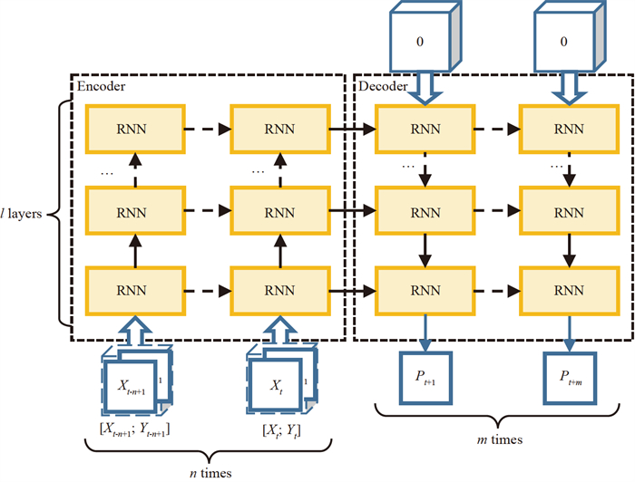
Weather radar echo extrapolation plays a crucial role in weather forecasting. However, traditional weather radar echo extrapolation methods are not very accurate and do not make full use of historical data. Deep learning algorithms based on Recurrent Neural Networks also have the problem of accumulating errors. Moreover, it is difficult to obtain higher accuracy by relying on a single historical radar echo observation. Therefore, in this study, we constructed the Fusion GRU module, which leverages a cascade structure to effectively combine radar echo data and mean wind data. We also designed the Top Connection so that the model can capture the global spatial relationship to construct constraints on the predictions. Based on the Jiangsu Province dataset, we compared some models. The results show that our proposed model, Cascade Fusion Spatiotemporal Network (CFSN), improved the critical success index (CSI) by 10.7% over the baseline at the threshold of 30 dBZ. Ablation experiments further validated the effectiveness of our model. Similarly, the CSI of the complete CFSN was 0.004 higher than the suboptimal solution without the cross-attention module at the threshold of 30 dBZ.
Weather radar echo extrapolation plays a crucial role in weather forecasting. However, traditional weather radar echo extrapolation methods are not very accurate and do not make full use of historical data. Deep learning algorithms based on Recurrent Neural Networks also have the problem of accumulating errors. Moreover, it is difficult to obtain higher accuracy by relying on a single historical radar echo observation. Therefore, in this study, we constructed the Fusion GRU module, which leverages a cascade structure to effectively combine radar echo data and mean wind data. We also designed the Top Connection so that the model can capture the global spatial relationship to construct constraints on the predictions. Based on the Jiangsu Province dataset, we compared some models. The results show that our proposed model, Cascade Fusion Spatiotemporal Network (CFSN), improved the critical success index (CSI) by 10.7% over the baseline at the threshold of 30 dBZ. Ablation experiments further validated the effectiveness of our model. Similarly, the CSI of the complete CFSN was 0.004 higher than the suboptimal solution without the cross-attention module at the threshold of 30 dBZ.




 粤公网安备 4401069904700002号