2021 Vol. 27, No. 2
2021, 27(2): .
Abstract:
2021, 27(2): 87-93.
doi: 10.46267/j.1006-8775.2021.009
Abstract:
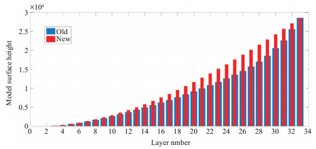
The calculation scheme of the smoothed-level and hybrid (SLEVE-hybrid for short) coordinates in numerical forecasting model is not limited in number. It is divided into the semi-analytical scheme and the finite differential scheme in terms of the various differential methods of the coordinate deformation variables. Having compared the dynamic equation and the long-time batch simulation results of the two schemes, the present study draws the following conclusions. The first-order finite difference accuracy of the coordinate deformation variables in the finite differential scheme is theoretically lower than that in the semi-analytical scheme. The larger the vertical gradient of the layer thickness is, the larger the relative errors of the finite differential scheme are. The long-time batch simulation test in the GRAPES model dynamic core demonstrates that the bias of the temperature and the geopotential height in the semi-analytical scheme is smaller under the default layering, while the simulation difference of the two schemes is greatly reduced when the layering is more uniform.
The calculation scheme of the smoothed-level and hybrid (SLEVE-hybrid for short) coordinates in numerical forecasting model is not limited in number. It is divided into the semi-analytical scheme and the finite differential scheme in terms of the various differential methods of the coordinate deformation variables. Having compared the dynamic equation and the long-time batch simulation results of the two schemes, the present study draws the following conclusions. The first-order finite difference accuracy of the coordinate deformation variables in the finite differential scheme is theoretically lower than that in the semi-analytical scheme. The larger the vertical gradient of the layer thickness is, the larger the relative errors of the finite differential scheme are. The long-time batch simulation test in the GRAPES model dynamic core demonstrates that the bias of the temperature and the geopotential height in the semi-analytical scheme is smaller under the default layering, while the simulation difference of the two schemes is greatly reduced when the layering is more uniform.
2021, 27(2): 94-108.
doi: 10.46267/j.1006-8775.2021.010
Abstract:
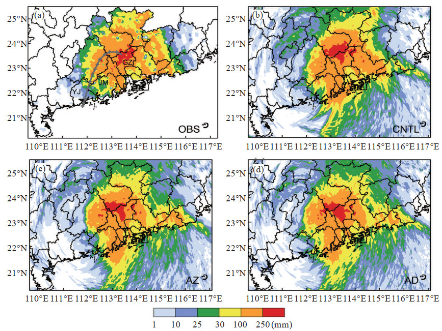
This study explores the potential for directly assimilating polarimetric radar data (including reflectivity Z and differential reflectivity ZDR) using an ensemble Kalman filter (EnKF) based on the Weather Research and Forecasting model to improve analysis and forecast of Tropical Storm Ewiniar (2018). Ewiniar weakened but brought about heavy rainfall over Guangdong, China after its final landfall. In the present study, two experiments are performed, one assimilating only Z and the other assimilating both Z and ZDR. Assimilation of ZDR together with Z effectively modifies hydrometeor fields, and improves the forecast of the intensity, shape and position of rainbands. Forecast of 24-hour extraordinary rainfall ≥250 mm is significantly improved. Improvement can also be seen in the wind fields because of cross-variable covariance. The current study shows the possibility of applying polarimetric radar data to improve forecasting of tropical cyclones, which deserves more research in the future.
This study explores the potential for directly assimilating polarimetric radar data (including reflectivity Z and differential reflectivity ZDR) using an ensemble Kalman filter (EnKF) based on the Weather Research and Forecasting model to improve analysis and forecast of Tropical Storm Ewiniar (2018). Ewiniar weakened but brought about heavy rainfall over Guangdong, China after its final landfall. In the present study, two experiments are performed, one assimilating only Z and the other assimilating both Z and ZDR. Assimilation of ZDR together with Z effectively modifies hydrometeor fields, and improves the forecast of the intensity, shape and position of rainbands. Forecast of 24-hour extraordinary rainfall ≥250 mm is significantly improved. Improvement can also be seen in the wind fields because of cross-variable covariance. The current study shows the possibility of applying polarimetric radar data to improve forecasting of tropical cyclones, which deserves more research in the future.
2021, 27(2): 109-124.
doi: 10.46267/j.1006-8775.2021.011
Abstract:
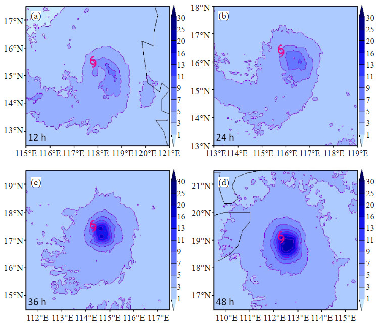
The impact of different cloud microphysics parameterization schemes on the intensity and structure of the Super-strong Typhoon Rammasun (1409) in 2014 is investigated using the Weather Research and Forecasting model version 3.4 with eight cloud microphysics parameterization schemes. Results indicate that the uncertainty of cloud microphysics schemes results in typhoon forecast uncertainties, which increase with forecast time. Typhoon forecast uncertainty primarily affects intensity predictions, with significant differences in predicted typhoon intensity using various cloud microphysics schemes. Typhoon forecast uncertainty also affects the predicted typhoon structure. Greater typhoon intensity is accompanied by smaller vortex width, tighter vortex structure, stronger wind in the middle and lower troposphere, greater height of the strong wind region, smaller thickness of the eyewall and the outward extension of the eyewall, and a warmer warm core at upper levels of the eye. The differences among the various cloud microphysics schemes lead to different amounts and distributions of water vapor and hydrometeors in clouds. Different hydrometeors have different vertical distributions. In the radial direction, the maxima for the various hydrometeors forecast by a single cloud microphysics scheme are collocated with each other and with the center of maximum precipitation. When the hydrometeor concentration is high and hydrometeors exist at lower altitudes, more precipitation often occurs. Both the vertical and horizontal winds are the strongest at the location of maximum precipitation. Results also indicate that typhoon intensities forecast by cloud microphysics schemes containing graupel processes are noticeably greater than those forecast by schemes without graupel processes. Among the eight cloud microphysics schemes investigated, typhoon intensity forecasts using the WRF Single-Moment 6-class and Thompson schemes are the most accurate.
The impact of different cloud microphysics parameterization schemes on the intensity and structure of the Super-strong Typhoon Rammasun (1409) in 2014 is investigated using the Weather Research and Forecasting model version 3.4 with eight cloud microphysics parameterization schemes. Results indicate that the uncertainty of cloud microphysics schemes results in typhoon forecast uncertainties, which increase with forecast time. Typhoon forecast uncertainty primarily affects intensity predictions, with significant differences in predicted typhoon intensity using various cloud microphysics schemes. Typhoon forecast uncertainty also affects the predicted typhoon structure. Greater typhoon intensity is accompanied by smaller vortex width, tighter vortex structure, stronger wind in the middle and lower troposphere, greater height of the strong wind region, smaller thickness of the eyewall and the outward extension of the eyewall, and a warmer warm core at upper levels of the eye. The differences among the various cloud microphysics schemes lead to different amounts and distributions of water vapor and hydrometeors in clouds. Different hydrometeors have different vertical distributions. In the radial direction, the maxima for the various hydrometeors forecast by a single cloud microphysics scheme are collocated with each other and with the center of maximum precipitation. When the hydrometeor concentration is high and hydrometeors exist at lower altitudes, more precipitation often occurs. Both the vertical and horizontal winds are the strongest at the location of maximum precipitation. Results also indicate that typhoon intensities forecast by cloud microphysics schemes containing graupel processes are noticeably greater than those forecast by schemes without graupel processes. Among the eight cloud microphysics schemes investigated, typhoon intensity forecasts using the WRF Single-Moment 6-class and Thompson schemes are the most accurate.
2021, 27(2): 125-135.
doi: 10.46267/j.1006-8775.2021.012
Abstract:
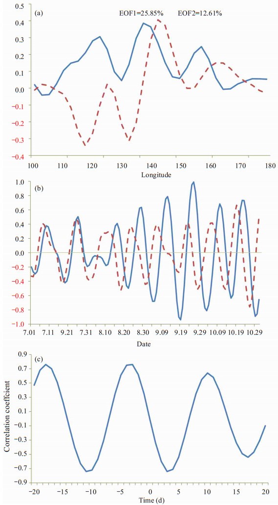
The quasi-biweekly oscillation (QBWO) is the second most dominant intraseasonal mode for circulation over the Northwestern Pacific (WNP) during boreal summer. In this study, we investigated how the QBWO modulates tropical cyclone (TC) activities over the WNP from dynamic and thermodynamic perspectives. The propagation of the QBWO can be divided into four phases through empirical orthogonal function analysis of the vorticity at 850 hPa, which was proven to be effective in extracting the QBWO signal. TC generation and landings are significantly enhanced during the active period (phases 1 and 2) relative to the inactive period (phases 3 and 4). Composite analyses show the QBWO could significantly modulate TC activity as it propagates northwestward by changing the atmospheric circulation at both high and low levels. Cumulus convection provides an important link between TCs and the QBWO. The major component of the atmosphere heat source is found to be the latent heat release of convection. The condensation latent heat centers, vertical circulation, and water vapor flux divergence cooperate well during different phases of the QBWO. The vertical profile of the condensation latent heat indicates upper-level heating (cooling) during the active (inactive) phases of the QBWO. Thus, the northwestward propagation of the QBWO can modulate TC activity by affecting the configuration of atmospheric heating over the WNP.
The quasi-biweekly oscillation (QBWO) is the second most dominant intraseasonal mode for circulation over the Northwestern Pacific (WNP) during boreal summer. In this study, we investigated how the QBWO modulates tropical cyclone (TC) activities over the WNP from dynamic and thermodynamic perspectives. The propagation of the QBWO can be divided into four phases through empirical orthogonal function analysis of the vorticity at 850 hPa, which was proven to be effective in extracting the QBWO signal. TC generation and landings are significantly enhanced during the active period (phases 1 and 2) relative to the inactive period (phases 3 and 4). Composite analyses show the QBWO could significantly modulate TC activity as it propagates northwestward by changing the atmospheric circulation at both high and low levels. Cumulus convection provides an important link between TCs and the QBWO. The major component of the atmosphere heat source is found to be the latent heat release of convection. The condensation latent heat centers, vertical circulation, and water vapor flux divergence cooperate well during different phases of the QBWO. The vertical profile of the condensation latent heat indicates upper-level heating (cooling) during the active (inactive) phases of the QBWO. Thus, the northwestward propagation of the QBWO can modulate TC activity by affecting the configuration of atmospheric heating over the WNP.
2021, 27(2): 136-147.
doi: 10.46267/j.1006-8775.2021.013
Abstract:
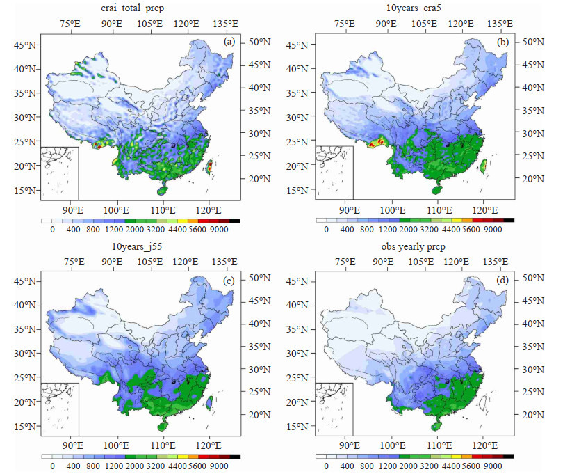
Based on the hourly observational data during 2007-2016 from surface meteorological stations in China, this paper compares the influence of 3-hourly precipitation data, mainly from the Chinese Reanalysis-Interim (CRA-Interim), ECMWF Reanalysis 5 (ERA5) and Japanese Reanalysis-55 (JRA-55), on the simulation of the spatial and temporal distribution of regional precipitation in China and the bias distribution of the simulation. The results show that: (1) The three sets of reanalysis datasets can all reflect the basic spatial distribution characteristics of annual average precipitation in China. The simulation of topographic forced precipitation in complex terrain by using CRA-interim is more detailed, while CRA-interim has larger negative bias in central and East China, and larger positive bias in southwest China. (2) In terms of seasonal precipitation, the three sets of reanalysis datasets overestimate the precipitation in the heavy rainfall zone in spring and summer, especially in southwest China. According to CRA-interim, location of the rain belt in the First Rainy Season in South China is west by south, and the summer precipitation has positive bias in southwest and South China. (3) All of the reanalysis datasets can basically reflect the distribution difference of inter-annual variation of drought and flood, but overall the CRA-Interim generally shows negative bias, while the ERA5 and JRA-55 exhibit positive bias. (4) For the diurnal variation of precipitation in summer, all the reanalysis datasets perform better in simulating the daytime precipitation than in the night, and the bias of CRA-interim is less in the Southeast and Northeast than elsewhere. (5) The ERA5 generally performs the best on the evaluation of quantitative precipitation forecast, the JRA-55 is the next, followed by the CRA-Interim. The CRA-Interim has higher missing rate and lower threat score for heavy rains; however, at the level of downpour, the CRA-Interim performs slightly better.
Based on the hourly observational data during 2007-2016 from surface meteorological stations in China, this paper compares the influence of 3-hourly precipitation data, mainly from the Chinese Reanalysis-Interim (CRA-Interim), ECMWF Reanalysis 5 (ERA5) and Japanese Reanalysis-55 (JRA-55), on the simulation of the spatial and temporal distribution of regional precipitation in China and the bias distribution of the simulation. The results show that: (1) The three sets of reanalysis datasets can all reflect the basic spatial distribution characteristics of annual average precipitation in China. The simulation of topographic forced precipitation in complex terrain by using CRA-interim is more detailed, while CRA-interim has larger negative bias in central and East China, and larger positive bias in southwest China. (2) In terms of seasonal precipitation, the three sets of reanalysis datasets overestimate the precipitation in the heavy rainfall zone in spring and summer, especially in southwest China. According to CRA-interim, location of the rain belt in the First Rainy Season in South China is west by south, and the summer precipitation has positive bias in southwest and South China. (3) All of the reanalysis datasets can basically reflect the distribution difference of inter-annual variation of drought and flood, but overall the CRA-Interim generally shows negative bias, while the ERA5 and JRA-55 exhibit positive bias. (4) For the diurnal variation of precipitation in summer, all the reanalysis datasets perform better in simulating the daytime precipitation than in the night, and the bias of CRA-interim is less in the Southeast and Northeast than elsewhere. (5) The ERA5 generally performs the best on the evaluation of quantitative precipitation forecast, the JRA-55 is the next, followed by the CRA-Interim. The CRA-Interim has higher missing rate and lower threat score for heavy rains; however, at the level of downpour, the CRA-Interim performs slightly better.
2021, 27(2): 148-160.
doi: 10.46267/j.1006-8775.2021.014
Abstract:
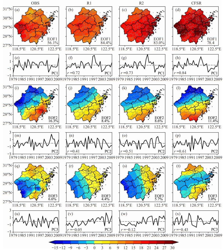
Based on various statistical indices, the abilities of multi-generation reanalyses, namely the NCEP / NCAR Reanalysis 1 (R1), the NCEP-DOE Reanalysis 2 (R2) and the NCEP Climate Forecast System Reanalysis (CFSR), to reproduce the spatiotemporal characteristics of precipitation over Zhejiang Province are comprehensively compared. The mean absolute bias percentages for three reanalyses are 20% (R1), 10% (R2) and 37% (CFSR). R2 (R1) gives the best (worst) general depiction of the spatial characteristics of the observed precipitation climatology, whereas a significant wet bias is noticed in the CFSR. All reanalyses reasonably reproduce the interannual variability with the correlation coefficients of 0.72 (R1), 0.72 (R2) and 0.84 (CFSR). All reanalyses well represent the first two modes of the observed precipitation through Empirical Orthogonal Function analysis, with CFSR giving the best capture of the principal components. The root-mean-square error (RMSE) is the largest (smallest) in the CFSR (R2). The large RMSE of CFSR in summer (especially in June) contributes mostly to its systematic wet bias. After 2001, the wet bias of CFSR substantially weakens, probably attributed to increasing observations assimilated in the CFSR. On a monthly basis, the percentage of neutral bias cases are similar for all reanalyses, while the ratio of positive (negative) bias cases for CFSR is distinctly larger (smaller) than that of R1 and R2. The proportions of negative bias cases for R1 and R2 begin to increase after 2001 while keeping stable for CFSR. On a daily basis, all reanalyses give good performances of reproducing light rain; however, the reflection of moderate rain and heavier rain by the CFSR is better than R1 and R2. Overall, despite being a third-generation reanalysis product, the CRSR does not exhibit comprehensive superiorities over R1 and R2 in all aspects on a regional scale.
Based on various statistical indices, the abilities of multi-generation reanalyses, namely the NCEP / NCAR Reanalysis 1 (R1), the NCEP-DOE Reanalysis 2 (R2) and the NCEP Climate Forecast System Reanalysis (CFSR), to reproduce the spatiotemporal characteristics of precipitation over Zhejiang Province are comprehensively compared. The mean absolute bias percentages for three reanalyses are 20% (R1), 10% (R2) and 37% (CFSR). R2 (R1) gives the best (worst) general depiction of the spatial characteristics of the observed precipitation climatology, whereas a significant wet bias is noticed in the CFSR. All reanalyses reasonably reproduce the interannual variability with the correlation coefficients of 0.72 (R1), 0.72 (R2) and 0.84 (CFSR). All reanalyses well represent the first two modes of the observed precipitation through Empirical Orthogonal Function analysis, with CFSR giving the best capture of the principal components. The root-mean-square error (RMSE) is the largest (smallest) in the CFSR (R2). The large RMSE of CFSR in summer (especially in June) contributes mostly to its systematic wet bias. After 2001, the wet bias of CFSR substantially weakens, probably attributed to increasing observations assimilated in the CFSR. On a monthly basis, the percentage of neutral bias cases are similar for all reanalyses, while the ratio of positive (negative) bias cases for CFSR is distinctly larger (smaller) than that of R1 and R2. The proportions of negative bias cases for R1 and R2 begin to increase after 2001 while keeping stable for CFSR. On a daily basis, all reanalyses give good performances of reproducing light rain; however, the reflection of moderate rain and heavier rain by the CFSR is better than R1 and R2. Overall, despite being a third-generation reanalysis product, the CRSR does not exhibit comprehensive superiorities over R1 and R2 in all aspects on a regional scale.
2021, 27(2): 161-168.
doi: 10.46267/j.1006-8775.2021.015
Abstract:
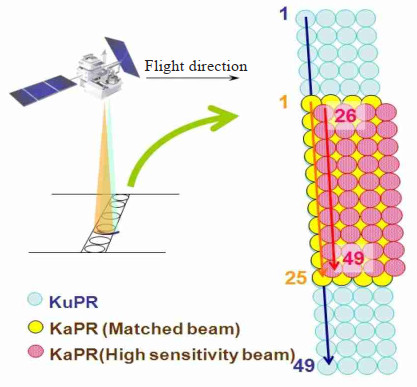
In this paper, we propose a fuzzy logic algorithm to recognize the types of hydrometeors by using Ka and Ku reflectivity factors, temperature thresholds and an asymmetric t-form membership function. The identifiable types of hydrometeors include snow, graupel, mixed-phase particles, large raindrops, and small raindrops. The reflectivity detection data of Ka and Ku with attenuation correction is from dual-frequency precipitation radar onboard the global precipitation measurement satellite. The temperature data from the European Centre for Medium-range Weather Forecasts are used to identify the hydrometeors, and the identified hydrometeors are compared with the vertical profiles of phase from official level-2 DPR products. The results show that the identified hydrometeors are reasonable and reveal the evolution process of tropical cyclones, which can be further applied to the study of precipitation microphysical process and artificial precipitation.
In this paper, we propose a fuzzy logic algorithm to recognize the types of hydrometeors by using Ka and Ku reflectivity factors, temperature thresholds and an asymmetric t-form membership function. The identifiable types of hydrometeors include snow, graupel, mixed-phase particles, large raindrops, and small raindrops. The reflectivity detection data of Ka and Ku with attenuation correction is from dual-frequency precipitation radar onboard the global precipitation measurement satellite. The temperature data from the European Centre for Medium-range Weather Forecasts are used to identify the hydrometeors, and the identified hydrometeors are compared with the vertical profiles of phase from official level-2 DPR products. The results show that the identified hydrometeors are reasonable and reveal the evolution process of tropical cyclones, which can be further applied to the study of precipitation microphysical process and artificial precipitation.
2021, 27(2): 169-176.
doi: 10.46267/j.1006-8775.2021.016
Abstract:
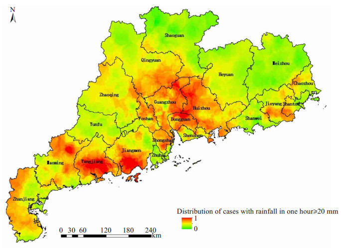
In the present study, a hazard model of severe convective weather was constructed on the basis of meteorological observational data obtained in Guangdong Province between 2003 and 2015. In the analysis, quality control was first conducted on the severe convective weather data, and the kriging method was then used to interpolate each hazard-formative factor. The weights of which were determined by applying the coefficient of variation method. The results were used to establish the hazard-formative factor model of severe convective weather. The cities showing the greatest hazards for severe convective weather in Guangdong Province include Yangjiang, Dongguan, Foshan, Huizhou, Jiangmen, and Qingyuan.
In the present study, a hazard model of severe convective weather was constructed on the basis of meteorological observational data obtained in Guangdong Province between 2003 and 2015. In the analysis, quality control was first conducted on the severe convective weather data, and the kriging method was then used to interpolate each hazard-formative factor. The weights of which were determined by applying the coefficient of variation method. The results were used to establish the hazard-formative factor model of severe convective weather. The cities showing the greatest hazards for severe convective weather in Guangdong Province include Yangjiang, Dongguan, Foshan, Huizhou, Jiangmen, and Qingyuan.
2021, 27(2): 177-190.
doi: 10.46267/j.1006-8775.2021.017
Abstract:
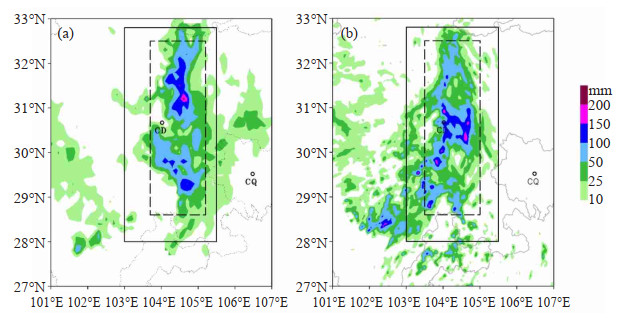
The structure and organization of the extreme-rain-producing deep convection towers and their roles in the formation of a southwest vortex (SWV) event are studied using the intensified surface rainfall observations, weather radar data and numerical simulations from a high-resolution convection-allowing model. The deep convection towers occurred prior to the emergence of SWV and throughout its onset and development stages. They largely resemble the vortical hot tower (VHT) commonly seen in typhoons or hurricanes and are thus considered as a special type of VHT (sVHT). Each sVHT presented a vorticity dipole structure, with the upward motion not superpose the positive vorticity. A positive feedback process in the SWV helped the organization of sVHTs, which in turn strengthened the initial disturbance and development of SWV. The meso-γ-scale large-value areas of positive relative vorticity in the mid-toupper troposphere were largely induced by the diabatic heating and tilting. The strong mid-level convergence was attributed to the mid-level vortex enhancement. The low-level vortex intensification was mainly due to low-level convergence and the stretching of upward flow. The meso-α-scale large-value areas of positive relative vorticity in the low-level could expand up to about 400 hPa, and gradually weakened with time and height due to the decaying low-level convergence and vertical stretching in the matured SWV. As the SWV matured, two secondary circulations were formed, with a weaker mean radial inflow than the outflow and elevated to 300-400 hPa.
The structure and organization of the extreme-rain-producing deep convection towers and their roles in the formation of a southwest vortex (SWV) event are studied using the intensified surface rainfall observations, weather radar data and numerical simulations from a high-resolution convection-allowing model. The deep convection towers occurred prior to the emergence of SWV and throughout its onset and development stages. They largely resemble the vortical hot tower (VHT) commonly seen in typhoons or hurricanes and are thus considered as a special type of VHT (sVHT). Each sVHT presented a vorticity dipole structure, with the upward motion not superpose the positive vorticity. A positive feedback process in the SWV helped the organization of sVHTs, which in turn strengthened the initial disturbance and development of SWV. The meso-γ-scale large-value areas of positive relative vorticity in the mid-toupper troposphere were largely induced by the diabatic heating and tilting. The strong mid-level convergence was attributed to the mid-level vortex enhancement. The low-level vortex intensification was mainly due to low-level convergence and the stretching of upward flow. The meso-α-scale large-value areas of positive relative vorticity in the low-level could expand up to about 400 hPa, and gradually weakened with time and height due to the decaying low-level convergence and vertical stretching in the matured SWV. As the SWV matured, two secondary circulations were formed, with a weaker mean radial inflow than the outflow and elevated to 300-400 hPa.




 粤公网安备 4401069904700002号